Hike Crack Canyon Trail in the San Rafael Swell
A narrow slot canyon through the San Rafael Reef presents several obstacles to negotiate on an otherwise straightforward out-and-back hike.
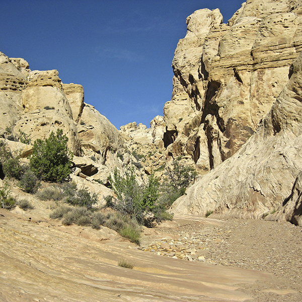
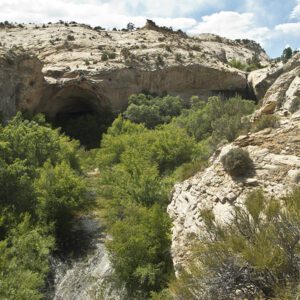
Starting at the mouth of the canyon, follow the 4WD road south. If you have an appropriate vehicle, you can drive another mile down canyon to the wilderness study area boundary and start walking from there. Heading into the canyon, cocoa-colored Chinle shale slopes angle into the ground ahead of you and the Wingate walls grow in stature.
Your hike through Crack Canyon starts on the eastern edge of the 75-mile-long sandstone dome known as the San Rafael Swell. This geologic feature begins north of I-70 and stretches south to the Henry Mountains, with jagged and near vertical slabs of sandstone forming the eastern flank. Early settlers called this sandstone ridge a “reef” for the navigational obstacles it presented. The settlers might not have known, however, that the San Rafael Reef actually has about 30 canyons that allow passage through the otherwise impenetrable rock.
After about 1 mile of hiking, you reach the Crack Canyon Wilderness Study Area boundary, at which point vehicles are prohibited.
Crack Canyon Wilderness Study Area and beyond
The Bureau of Land Management has established six wilderness study areas in the San Rafael Swell with Crack Canyon being one of them. As you pass the boundary at the wooden fence, tucked among large cottonwood trees, you enter this special place.
Shadows hide in pockets and holes, and the sculpted walls remind you of water’s powerful force in an arid environment. As the calico walls narrow, rocks and debris cover the canyon floor. Watch for a cairned route a quarter-mile farther, which bypasses a pouroff on the left.
Proceeding downcanyon, you pass through several narrows sections. The first, at 1.5 miles, has a short stretch of overhung walls, creating a miniature subway of slickrock. A little farther and you begin hiking down a series of drops, where boulders and logs have jammed the canyon. Difficulty of the downclimbs varies, as both the canyon and wash bottom change with every flash flood. You might find strategically placed driftwood or stacked rocks to help you negotiate the boulders, which are likely larger than you. Remember an important rule in canyoneering: don’t descend if you question your ability to climb back up. Since this is an out-and-back hike, you can turn around at any point.
A choke stone creates a 10-foot drop, the most significant obstacle of the hike. A rope left behind by fellow hikers helps you down to the pit below, which may or may not have water in it.
After 3 miles, you exit the narrows. The canyon widens, transitioning from sheer, tall walls to stubby Navajo Sandstone knobs and fins. The canyon diminishes as it enters the San Rafael Desert, the arid, featureless badlands east of the Swell. Continue walking through the canyon until you decide to turn back.
Directions to the Crack Canyon Trail
From Hanksville, Utah, drive 19.5 miles north on UT 24. Just past mile marker 136, turn left onto Temple Mountain Road following the sign towards I-70, GoblinValley, and TempleMountain. Drive 5 miles along this road before reaching the turnoff to GoblinValleyState Park, Bell, and Little Wild Horse Canyon to your left. Continue straight past this intersection into the San Rafael Reef, with the pavement ending in another 1.5 miles. At 26.9 miles, turn left on the unsigned dirt road known as Behind the Reef Road. Follow its meanders around sandstone cliffs and Chinle hills, reaching the CrackCanyon trailhead at 31.1 miles. Pull into the dirt parking area just left of the road; a BLM sign and map mark the trailhead.
General Location Hanksville, Utah
Distance 6.9 miles (11.1 km)
Difficulty Moderate
Trailhead Elevation 5,500 ft (1,676 m)
Highest/Lowest Elevation 5,500/5,000 ft (1,676/1,524 m)
Managed By Bureau of Land Management
Fees No fee – Check the website below for current information.
Pets Allowed
More Info BLM website
Adventure awaits
Sign up to get three hikes in your inbox every month for a year.

Special membership offer
Join the Grand Canyon Trust today to receive your adventure kit:
- $25 donation: a Grand Canyon map, The Advocate magazine subscription, bookmark, and sticker
- $75 donation: everything above plus four stunning note cards
- $100 donation: all the benefits of the $75 level, plus a Grand Canyon Trust hat
Related Hikes by Destination
Sites: 25
Season: Open year-round
Reservations: For groups sites only
Distance: 8 mi (12.9 km)
Difficulty: Easy
Type: Out and back
State: Utah
Nearest Town: Springdale, Utah
Distance: 2.2 mi (3.5 km)
Difficulty: Moderate
Type: Out and back
