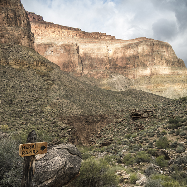
Escape the hubbub of the South Rim on the Hermit Trail
Hike to the Colorado River on the Hermit Trail on this quieter South Rim alternative.
The park’s main corridor trails have their perks — wide paths, rest houses, and water stations. But if you’re looking to break free of the hordes of people and mule droppings on the Bright Angel and South Kaibab trails, you best leave Grand Canyon Village.
The Hermit Trail was actually born out of this very desire. In 1911, the Santa Fe Railroad began developing the Hermit Basin as an alternative to the Bright Angel Trail, which was then operating as a toll road. Much of the Hermit Trail is rocky and eroded today, but a few sections of hand-fitted rock slabs hint at its former life as the South Rim’s state of the art rim-to-river-route that serviced a luxury camp along Hermit Creek in the early 20th century.
Note: This trail is a rim-to-river hike that is completed as part of a backpacking trip. For day hikers, a good turnaround point is Santa Maria Spring (5 miles roundtrip).
Hike the Hermit Trail
From the trailhead, follow the gravel path south, beginning a steep and steady descent through the upper rock layers — Kaibab Limestone, Toroweap Formation, and Coconino Sandstone. Switchbacks intensify as you drop through the Coconino, easing up as you hit the rusty-colored Hermit Shale. At 1.3 miles you reach the junction with the Waldron Trail, which comes in from the left. Continue straight (west) on the Hermit Trail, and in a half mile you reach another junction with the Dripping Spring Trail. Veer right to stay on the Hermit.
Santa Maria Spring
Nearing the head of the Hermit Creek Gorge, the trail descends into the Supai Formation via a few switchbacks. You arrive at Santa Maria Spring and rest house around 2.5 miles. Water usually trickles into a metal trough, but the spring is not considered a permanent water source. Don’t count on finding water here, and treat all water before drinking. The brick rest house was originally built at the same time as the trail, and its cool shade permits a moment of respite on the “Restbit bench.”
If you’re day hiking, this is a great destination; turn around and retrace your steps back up the Hermit Trail.
Long Supai traverse
From Santa Maria Spring and rest house, the trail hugs the right canyon wall in a long traverse through the Supai Formation. Frequent gullies cut into the slope at perpendicular intersections, forcing you to pick your way across sketchy rockslides. The route through these boulder areas can be difficult to discern, so look for cairns and follow your best judgment when necessary.
A series of switchbacks drops you down to Lookout Point, where the trail crosses a saddle between the canyon wall and a blocky Supai knob. The traverse continues at more or less a level elevation, but watch out for the worst gully detour just before reaching Cathedral Stairs, the name for the brutal descent that awaits.
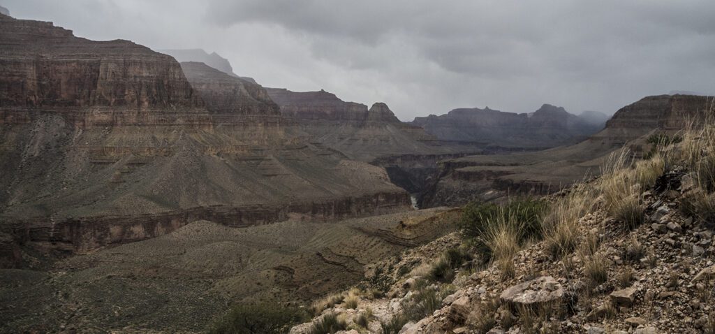
Cathedral Stairs to the Tonto Trail
Rocky switchbacks cut through the Redwall Limestone, weaving past spires and towers as you make your way down to the talus slope below Cope Butte. From here, follow the sweeping switchbacks down the scree pile until you hit the Tonto Trail (7 miles from the trailhead).
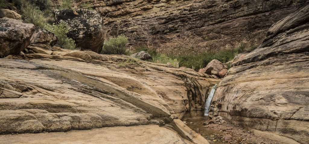
Down to Hermit Creek and Hermit Rapid
At the junction with the Tonto, turn left (west) and follow signs towards Hermit Creek. The grade of the trail eases for the next half mile, until you are simply contouring along the canyon wall.
For people camping at the river (BM8): A cut-off trail breaks off to the right towards Hermit Rapid. Drop down to the bottom of the canyon, and continue downstream until you reach the Colorado River. Cairns mark shortcuts across the banks, but rockhopping along the stream bed will get you there too.
For people camping at Hermit Creek (BM7): Stay straight at the cut-off trail junction, and continue contouring back into the drainage. You pass remnants of the historic Hermit Camp, which in the 1920s included an aerial tramway and Fred Harvey Company chef! Today, you can still see foundations, cisterns, and the lower terminus of the tramway. The trail eventually drops down to creek level around 8.2 miles, where you’ll find today’s National Park Service campsites — with the only amenities being a single pit toilet.
From the Hermit Creek campsites, you can continue 1.5 miles downstream to reach the Colorado River at Hermit Rapid. The gorge in the Tapeats Sandstone is beautiful, and you’ll get to see some small waterfalls along the way!
Water sources along the Hermit Trail
Hermit Creek and the Colorado River are the main sources of water here. Purify and filter all water before drinking.
Directions to the Hermit Trail
Hermits Rest, the last viewpoint on the west end of Hermit Road, serves as the trailhead for this hike. Hermit Road is open only to shuttle busses from March 1 to November 30. You can park your vehicle at the Backcountry Office in the village and take the free and frequent shuttle bus (Red Route) to Hermits Rest (last stop) at the end of Hermit Road.
Or, with your backcountry permit for either of these trails during those months, you may drive your private vehicle to the trailhead. Just punch the numerical code (printed on your permit) into the keypad, pass through the gate, and follow the road west to Hermits Rest. Once there, follow a signed dirt road for a quarter mile to the parking area. Check the park website for current information about driving your car or taking the shuttle.
General Location Grand Canyon National Park
Distance 9.7 miles (15.6 km) one way
Difficulty Strenuous
Trailhead Elevation 6,670 ft (2,033 m)
Highest/Lowest Elevation 6,670/2,320 ft (2,033/707 m)
Fees Park entrance fee required. Camping below the rim requires backcountry permits and additional fees. Check the website below for current information.
Pets Not Allowed
More Info NPS website
Adventure awaits
Sign up to get three hikes in your inbox every month for a year.

Special membership offer
Join the Grand Canyon Trust today to receive your adventure kit:
- $25 donation: a Grand Canyon map, The Advocate magazine subscription, bookmark, and sticker
- $75 donation: everything above plus four stunning note cards
- $100 donation: all the benefits of the $75 level, plus a Grand Canyon Trust hat
Related Hikes by Destination

Distance: Up to 13 miles
Difficulty: Easy
Type: Point-to-point

Distance: 6.6 miles (10.6 km) one way
Difficulty: Moderate
Type: Out and back

Distance: 9.5 miles (15.3 km)
Difficulty: Strenuous
Type: One way

Distance: 27.9 miles
Difficulty: Strenuous
Type: Out and back