Hike the Mt. Ellen Summit Trail to the top of the highest peak (11,480 feet) in the isolated Henry Mountains
While it takes awhile to drive to the trailhead, the Mt. Ellen Summit Trail is a relatively quick walk.
A faint footpath leaves from the parking area and starts climbing the ridgeline ahead of you. For the first mile, the trail gradually gains elevation and skirts the left side of the ridge. Expansive views immediately fill the horizon to the west — Capitol Reef National Park, the Waterpocket Fold, and Thousand Lake Mountain. You can see a few roads leading down the west side of the mountain into an area of Mancos shale badlands known locally as the Blue Hills.
Remote Henry mountains
Rising more than 6,000 feet from the red rock desert below, the Henry Mountains are one of the most prominent features in the panorama of southeastern Utah but were the last mountain range to be added to the map of the continental United States. They remain just as remote today, as the rugged route you took to get to the trailhead proves.
Back on the trail, you can see aspen groves below you. You pass through a pocket of spruce and fir trees around 0.75 mile, but vegetation is scarce above 10,500 feet. Grass and small tundra flowers manage to grow between rocks in scant pockets of soil, enduring the harsh conditions that you may encounter on this hike above treeline: strong wind, cold temperatures, possibly snow.
Follow North Summit Ridge to the peak
After passing through the trees, the trail cuts up to the top of North Summit Ridge. Rocks are loose, so be careful on the steep slopes. Supportive shoes are a must. When you get to the top of the ridge at 1.3 miles, the trail disappears among the rock piles. From here, you can simply walk freely along the undulating ridgeline to the summit.
Panoramic views all around
The panoramic views from this ridge encompass a landscape of wine-colored rocks that glow shades of pinks and reds and diffuse the afternoon sun. Ahead of you to the north is the blue-gray badlands of the San Rafael Desert and the swath of eroded sandstone uplift known as the San Rafael Swell. The Henrys stretch to the south, with the lesser peaks of Mt. Pennell and Mt. Hillers behind you. Mt. Holmes and Mt. Ellsworth, the last of the string of peaks, rise independently to the southeast.
Look to your right for views of Sawmill Basin descending steeply to the east. This area, along with the entire range, contains several intrusions that form the skeleton of the Henry Mountains. Called laccoliths, the Henrys formed when magma pushed up from the earth’s depths, creating domes of volcanic rock beneath the bowed sedimentary layers. Erosion eventually exposed the volcanic intrusion underneath. The road along Sawmill Basin marks the transition from the sandstone-covered lower elevations to the rugged volcanic rock you’re hiking on.
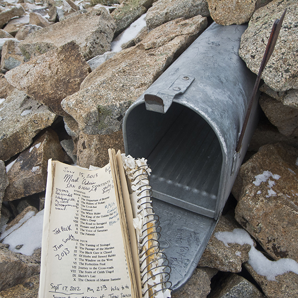
Leading up to the summit, you find hiker-made rock shelters to block the wind. Around 2 miles, you arrive at a mailbox concealed in the rocks—look for the vertical red flag. Inside is a canister, and inside of that is a logbook that contains entries from other hikers scrawled in the margins.
When you’ve gotten chilled from the cold wind or are ready to head back, follow the ridge south back to Bull Creek Pass to return to your vehicle.
Directions to the trailhead
From Hanksville, Utah, drive south on UT 95, and turn right on a dirt road just before mile marker 10. Reset your odometer, and follow the road towards Granite and Farview Ranch.
Note: the soils in the area have a high clay content, so avoid driving to the trailhead in wet conditions; snow may block passage even into early summer, and summer monsoons may also wash out roads or cause rockslides. These roads are not regularly maintained. Before setting out, inquire at the Bureau of Land Management office in Hanksville about current conditions.
After traveling on the dirt road for 2.7 miles, you pass the private Granite Ranch on your left; follow the sign to the right towards Lonesome Beaver Campground. When you reach a junction with Sawmill Basin Road at 6.2 miles, turn left, and continue to Sawmill Basin and Lonesome Beaver Campground, 8 and 10 miles farther respectively.
Around 14 miles, you cross Bull Creek. Shortly thereafter, you enter Sawmill Basin, which you drive through and follow all the way up to the trailhead at Bull Creek Pass. The rocky road continues past Dandelion Flat Picnic Area. At 15.2 miles, you reach a sign that lists mileages to Lonesome Beaver Campground, Wikiup Pass, and Bull Creek Pass.
When you arrive at Wikiup Pass, make a final right turn and contour along the side of the basin. A BLM sign marks Bull Creek Pass at 10,500 feet elevation. Across the road, at 19.9 miles, a fenced parking area and trail register box mark the trailhead to Mt. Ellen.