Map of Proposal to Dam the Little Colorado River (Project 2)

Map of the proposed Little Colorado River dam project showing the little Colorado River, the gorge, and where dams and reservoirs would go

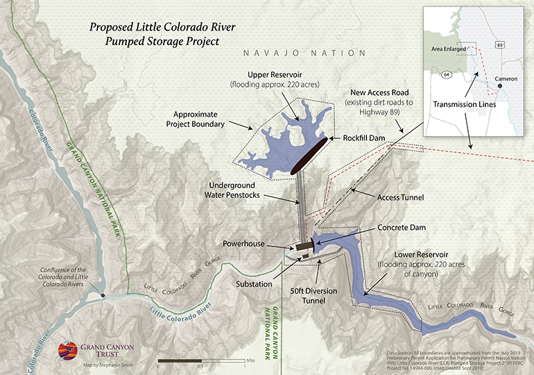
A Phoenix company has proposed two hydroelectric projects (each with two dams) in the Little Colorado River Gorge, mere miles from Grand Canyon National Park. This one, the Little Colorado River Pumped Storage Project, would flood a site sacred to the Hopi, half a mile from the park boundary.

Map of the proposed Little Colorado pumped storage project.

Download a PDF of this map

Maps and graphs may be used for non-commercial purposes provided that they are not altered or edited and they are appropriately credited.

All map products should be credited to Stephanie Smith, Grand Canyon Trust, unless otherwise noted. A hyperlink to the Grand Canyon Trust website is appreciated.

For higher quality images or custom sizing please contact our communications director, Ashley Davidson, at adavidson@grandcanyontrust.org

Related Resources

Dragon Bravo Fire Map showing the locations and burn perimeters of the White Sage and Dragon Bravo wildfires in 2025 near Grand Canyon National Park and Kaibab National Forest, with affected areas shaded in orange.
See a map of the areas the Dragon Bravo and White Sage fires burned on the north rim of the Grand Canyon in the summer of 2025, destroying the lodge and numerous other park buildings.