Proposed Hydropower Dams by Water Requirement Map

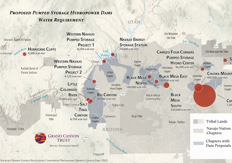
A number of pumped storage hydroelectric projects have been proposed on or near Native lands across the Colorado Plateau. This map shows how much water each project would require to initially fill its reservoirs. Download your copy of this map ›

Curious about pumped storage? Here’s how it works ›

Water requirements for proposed pumped storage hydroelectric projects on Native lands. Map by Stephanie Smith

Download your copy of this map ›

Resource - map credit Stephanie Smith

Maps and graphs may be used for non-commercial purposes provided that they are not altered or edited and they are appropriately credited. All map products should be credited to Stephanie Smith, Grand Canyon Trust, unless otherwise noted. A hyperlink to the Grand Canyon Trust website is appreciated.

For higher quality images or custom sizing please contact our communications director, Ashley Davidson, at adavidson@grandcanyontrust.org.

Related Resources

This map shows the risk of fatal accidents along the more than 300-mile transportation route from Canyon uranium mine (renamed Pinyon Plain Mine) near the Grand Canyon to the White Mesa uranium mill. Four of the five most dangerous sections along the route are on the Navajo Nation. See a photo gallery of the haul route, […]

This map shows active mining claims, including various uranium mines, inside the boundaries of Baaj Nwaavjo I’tah Kukveni Grand Canyon National Monument The map was produced using data from the Bureau of Land Management and updated in June 2024.   Download a PDF of the map › Maps and graphs may be used for non-commercial purposes […]