White Mesa Cultural Conservation Area – 2015 Project Sites

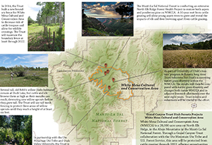
The Grand Canyon Trust maintains the 28,000-acre White Mesa Cultural and Conservation Area in the Manti-La Sal National Forest of central Utah in collaboration with the Ute Mountain Ute Tribe and U.S. Forest Service. View the map and projects ›

View the projects

Download your copy ›

Resource - map credit Stephanie Smith

Maps and graphs may be used for non-commercial purposes provided that they are not altered or edited and they are appropriately credited. All map products should be credited to Stephanie Smith, Grand Canyon Trust, unless otherwise noted. A hyperlink to the Grand Canyon Trust website is appreciated.

For higher quality images or custom sizing please contact our communications director, Ashley Davidson, at adavidson@grandcanyontrust.org.

Related Resources

Map showing the North Rim Lands of the Grand Canyon in Arizona, highlighting national parks, forest service areas, tribal lands, monuments, and Bureau of Land Management.
Map of the Grand Canyon Trust’s North Rim Ranches located on the North Rim of the Grand Canyon.

Research indicates that pinyon jays have declined as much as 80% and are one of the most rapidly declining bird species in North America. Download the PDF ›  

Join our community science project to help protect pinyon jays and pinyon and juniper forests. Start your online training today.