Bullet Canyon is a great introduction to the cultural history protected within Bears Ears National Monument
Enjoy searching for Ancestral Puebloan history on the ledges and alcoves of Bullet Canyon.
Grand Gulch and its tributaries, which include Bullet Canyon, form an extensive drainage network famous for its concentration of Ancestral Puebloan sites. Throughout your hike, scan the canyon walls for cliff dwellings, artifacts, and rock art. You can find most sites tucked in alcoves and underneath overhanging cliffs, and this hike leads you to two major ones. As you visit them, remember that these cultural sites are alive and important to tribes today. Please visit respectfully.
The trail into Bullet Canyon is a well-worn dirt path along the top of the juniper-and-piñon-studded Cedar Mesa. A dark, lumpy crust of cryptobiotic soil blankets the ground as far as you can see, forming a living groundcover of cyanobacteria, algae, and lichens. Grand Gulch is a Wilderness Study Area, so watch your step and “don’t bust the crust.”
Descend into Bullet Canyon
After 0.3 mile, you arrive at Bullet Canyon’s rim. Cairns mark the slickrock route down, with the trail winding around sandstone ledges and zigzagging between trees. When you reach the wash bottom, turn right and continue west downcanyon. If completing the trip as a day hike, be prepared for a demanding and strenuous trip. The boulder-choked and densely vegetated canyon makes for slow hiking.
You’ll want to avoid walking directly in the middle of the wash since it’s thick in tamarisk trees, willows, and tall grasses. Higher up on the banks, sandy trails steer clear of the dense vegetation.
As you near 0.9 mile, keep your eyes high on the right wall for a crumbling pueblo. The Ancestral Puebloans cut sandstone into building blocks and used a mud-based mortar to construct their dwellings. A spur trail leads to the base of this site, but it’s perched high on a rock island separate from the main canyon walls, making it difficult to investigate up close.
The trail then tunnels through willows and grasses that line the banks. Around 1.5 miles you pass two staggered alcoves on each side of the canyon that provide shady rest areas. The canyon cuts deeper into the sandstone as you approach a series of pouroffs, and from here, the walls only grow in height.
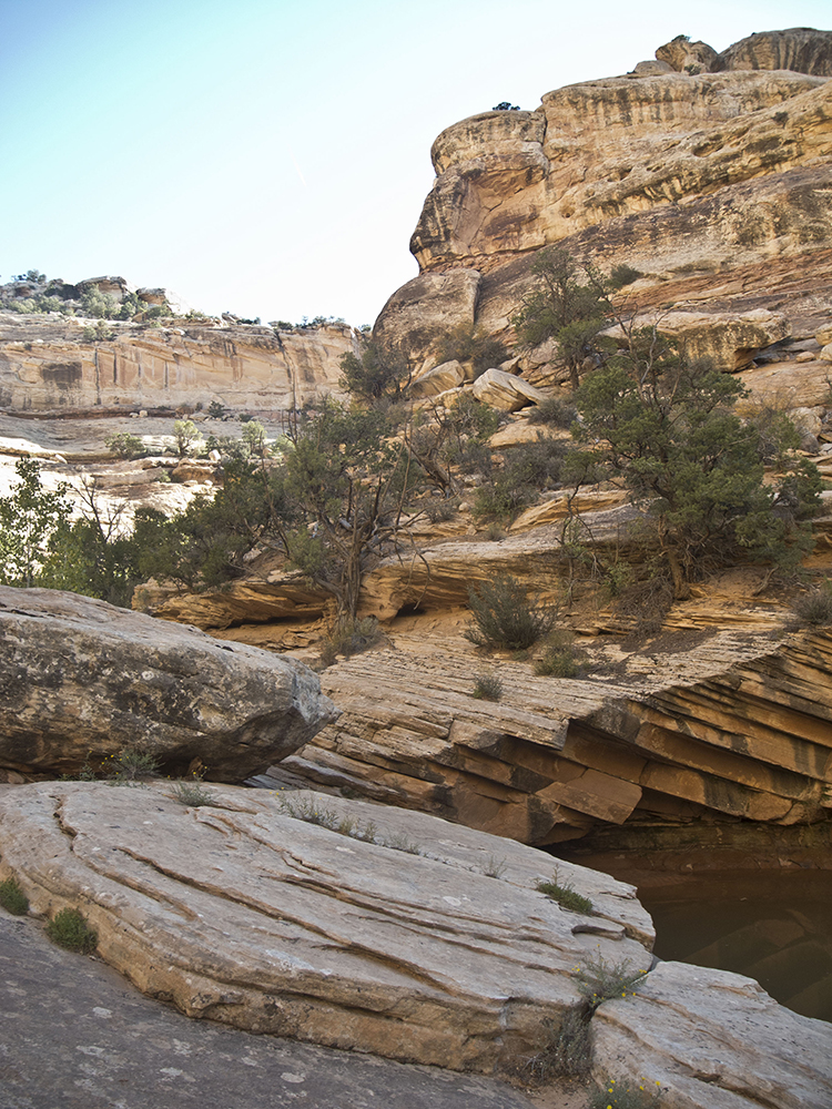
Down the pouroff
Around 1.8 miles, you drop steeply down several pouroffs. You can bypass the first slickrock chute by following a cairned route on your right, but unless this section is wet or icy, you should be able to negotiate down the thin terraced ledges. The chute continues with sandy patches between dropoffs that form steps down to the canyon floor.
The walls now tower above you, and as you follow the wash west, the canyon continues to narrow. Small cairns camouflaged in the rocky wash direct you around massive boulders and pools of stagnant water. Near 2.4 miles, the canyon becomes crowded with SUV-sized boulders. Take the high cairned route on the right wall for the easiest travel. Along this route, you hug sheer canyon walls and walk on a ledge with steep dropoffs to the canyon floor. The climb back down to the wash can be precipitous, so watch your step.
After a half mile of scrambling around boulders and trees, the wash bottom finally mellows into fields of tall grasses and horsetails that loom over your head. Gambel oaks line the banks, and a side drainage joins in from the left around 3.3 miles. Bear right to continue heading west in the main canyon.
Finding Perfect Kiva
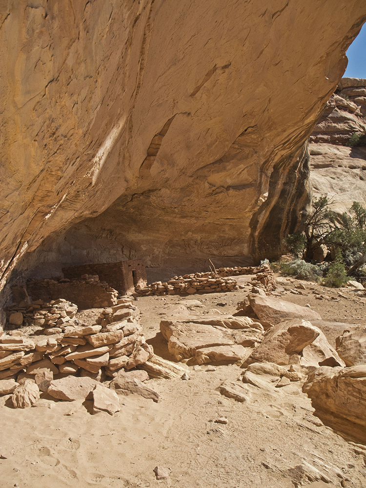
When you first see the ancient, enduring stonework, your venture into Bullet Canyon becomes more than a hike — it’s a cultural exploration filled with discovery and wonder. And one of the greatest discoveries is the site named Perfect Kiva. To locate it, keep scanning the canyon wall on your right after every bend in the wash. It isn’t visible from the main canyon, so look for a cairned route that leads into a south-facing alcove near 4.6 miles. An arched overhang midway up the wall serves as your reference point while you climb up a steep, rocky drainage to reach the site.
At the site, you see bases of masonry structures and the tip of a wood ladder dropping into Perfect Kiva. The BLM has reinforced the roof of this underground circular room, and visitors can climb down the ladder and see the original construction techniques used by the people who lived here many centuries ago. Such chambers still exist in modern-day pueblos and are used for ceremonies and other gatherings.
Visiting Jailhouse Ruin
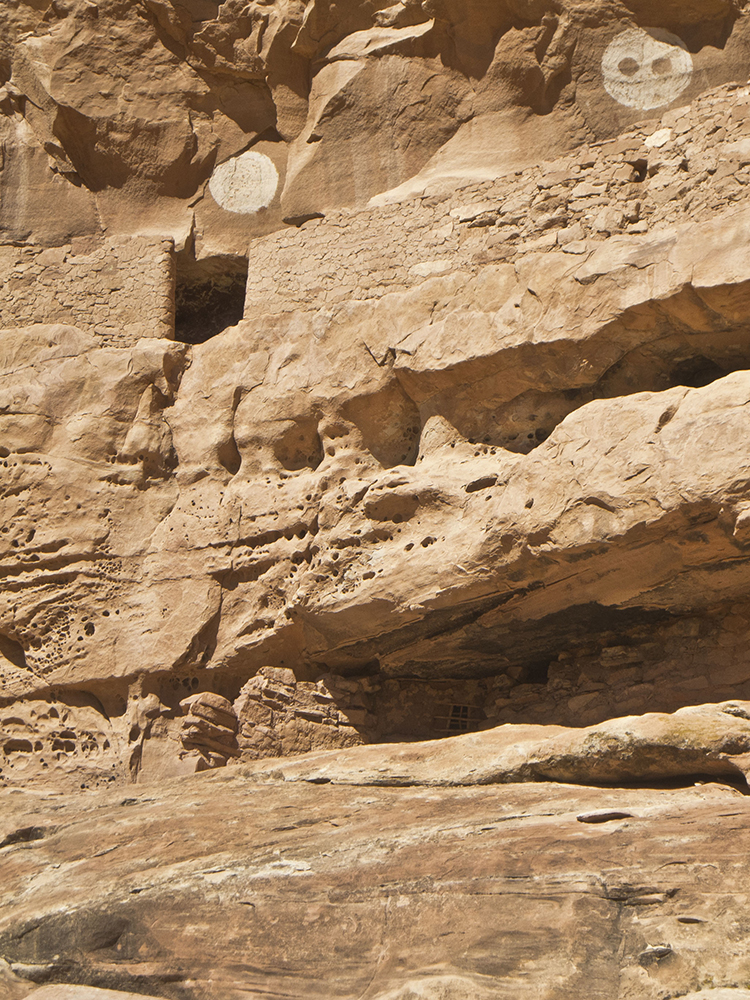
After making your way back into the main canyon, round the next bend of the wash and search the right canyon wall for three white circles above an alcove—pictographs that identify the site called Jailhouse Ruin from the main canyon. Continue heading towards the three white circles until you find the footpath that leads to the alcove (around 5 miles). You must find your own route up the slickrock bowl to reach the site.
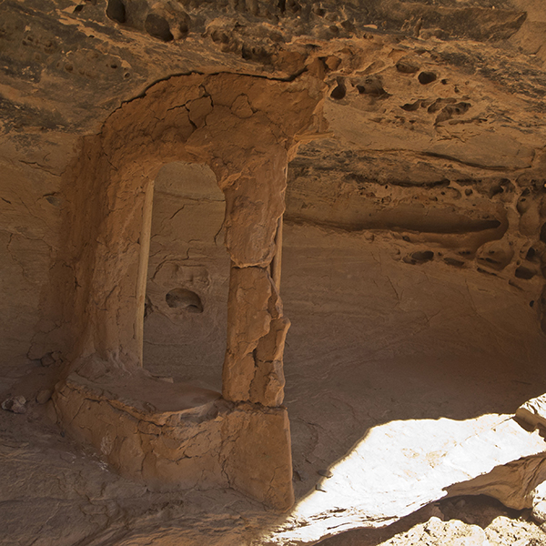
Jailhouse Ruin gets its name from the barred window into a small chamber. Archaeologists remain uncertain as to the purpose of the dwelling, but it’s intriguing to imagine the Ancestral Puebloans building and using the site 800 to 2,000 years ago.
Bullet Canyon joins Grand Gulch in another 2 miles, providing opportunities for extended backpacking trips in this culturally rich area. If you are hiking this as a day trip, return the way you came.
Directions to the trailhead
From Blanding, Utah, drive south on Hwy 191 until you reach the junction with UT 95. Turn right, and continue for about 32 miles. When you reach UT 261, turn left and reset your odometer. Heading south, pass Kane Gulch Ranger Station on your left at 3.8 miles. Around 11 miles, turn right on CR 251, the dirt road that leads to Bullet Canyon trailhead. A BLM sign marks the turnoff. About 1.5 miles down the dirt road, you reach the trailhead that has a pit toilet, maps, and informational signs. If you didn’t stop at the ranger station to purchase a hiking permit, you can use the self-pay station located to the left of the trail register box.
General Location Bears Ears National Monument
Distance 10.8 miles (17.4 km)
Difficulty Strenuous
Trailhead Elevation 6,400 ft (1,950 m)
Highest/Lowest Elevation 6,400/5,500 ft (1,950/1,676 m)
Managed By Bureau of Land Management
Fees Day pass or backcountry permit required. Check the website below for current information.
Pets Not Allowed
More Info BLM website
Adventure awaits
Sign up to get three hikes in your inbox every month for a year.

Special membership offer
Join the Grand Canyon Trust today to receive your adventure kit:
- $25 donation: a Grand Canyon map, The Advocate magazine subscription, bookmark, and sticker
- $75 donation: everything above plus four stunning note cards
- $100 donation: all the benefits of the $75 level, plus a Grand Canyon Trust hat
Related Hikes by Destination

Distance: 3.4 miles (5.5 km)
Difficulty: Moderate
Type: Out and back

Distance: 15.6 miles (25.1 km)
Difficulty: Strenuous
Type: Loop hike

Distance: 8.2 miles (13.2 km)
Difficulty: Strenuous
Type: Out and back

Distance: 4.4 miles (7 km)
Difficulty: Moderate
Type: Out and back