See petroglyphs and expansive views on this section of the Flagstaff Loop Trail
The 44-mile Flagstaff Loop Trail encircles town and links many established trails and roads. The section described here begins at the Sandy Seep Trailhead and shares the Picture Canyon and Arizona Trail equestrian bypass for the first few miles. After crossing under the freeway, it joins the Anasazi Loop Trail on Campbell Mesa.
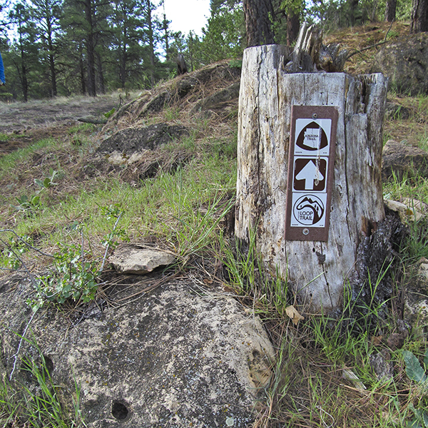
The trail leaves the Sandy Seep Trailhead, and reaches a junction in 0.1 mile with a sign for both the Arizona and Loop trails. Go left for the section of the Flagstaff Loop section described here.
The trail heads south on its way towards a culvert where it goes under the highway. After the culvert, you wander across a gently rolling landscape dotted with oak groves, ponderosa pines, and small meadows. In about a mile, homes in a subdivision appear on the left, and you reach the entrance to the Picture Canyon Natural and Cultural Preserve.
Picture Canyon
The Picture Canyon Natural and Cultural Preserve, which was originally state land, was acquired by the City of Flagstaff in 2012 for $4.8 million dollars, using the proceeds of a voter-approved open space bond and a Growing Smarter Grant. Picture Canyon was named by Museum of Northern Arizona founder Harold S. Colton, who excavated some of the archaeological sites in 1919 and 1921. He also described many of the rock art panels found in the canyon; in 2008 more than 125 panels were located and recorded, and the canyon was listed on the National Register of Historic Sites in that year.
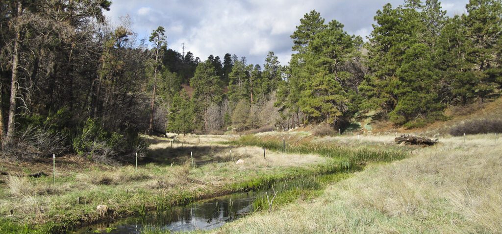
Rio de Flag
Leaving the entrance behind, the Loop Trail strikes off towards the southeast, skirting the east side of Sheep Hill and working across several small drainages. At 2 miles, the trail reaches the Rio de Flag and the small bridge that crosses it. A trail going left just before the bridge will take you to some petroglyphs a few hundred feet downstream. They are scattered along a rock outcrop on the left side of the trail.
The Rio de Flag flows year-round through Picture Canyon, fed by the Wildcat Hills water treatment plant just upstream. A project began in 2008 to restore the Rio’s natural meanders and riparian vegetation. More than 130 species of birds, including four woodpeckers, elk and deer, gray foxes, skunks and raccoons, and pack rats now frequent this oasis. At 2.4 miles, an old road comes in from the right, which leads to a waterfall (0.25 mile) in the narrowest part of Picture Canyon.
Rain Valley
After crossing a power line right-of-way, the trail bends right and part of the Wildcat Hill cinder pit becomes visible. Go through a gate and follow a somewhat mysterious berm that makes several twists and turns. The trail then crosses the flat, wide-open floor of Rain Valley. After going through a second gate, the trail reaches Mickelson’s Road (FR 791).
The Arizona Trail equestrian bypass, which has shared the Loop Trail since leaving the Sandy Seep Trailhead four miles ago, continues straight ahead, while the Flagstaff Loop Trail goes to the right. Turn right on the road and follow it to the highway, where you go left, crossing the railroad tracks on an overpass. Go through a gate on the right a few hundred feet beyond the overpass, and follow the trail as it descends into a drainage. A second gate and two large concrete culverts take you under the freeway.
Campbell Mesa
After the freeway, the trail heads southwest across Campbell Mesa, named after Hugh E. Campbell, a sheepman who grazed the area in the early 1900s. At 5.3 miles, you reach the junction with the Campbell Mesa Loop Trail; go right.
Another junction appears at 6.1 miles, where the Anasazi Loop Trail comes in from the left; continue straight ahead. Take time to enjoy the widely spaced trees, grassy meadows, and clumps of Gambel oaks. Campbell Mesa wasn’t always such a pleasant place. After the logging ended, numerous roads appeared, along with trash, fire rings, and illegal dumps. In 2002, the Coconino National Forest began closing roads and with the help of volunteers cleaned up the trash.
The other end of the Anasazi Loop Trail comes in from the right at 7.1 miles, and within 0.2 mile you reach the trailhead. Follow the graded road another few hundred yards to the parking lot and gate next to Walnut Canyon Road.
Directions
Sandy Seep Trailhead: From downtown Flagstaff, drive east 6.8 miles on Route 66 (US Highway 89) past the Flagstaff Mall and 0.5 mile past the Townsend-Winona intersection to a dirt road (FR 9139) on the left, which will take you to the trailhead. There is a brown Forest Service trailhead sign on the right side of the highway just before you reach the road on the left to the trailhead.
Campbell Mesa Trailhead: From downtown Flagstaff, drive east 4.5 miles on East Route 66 (US Highway 89); turn right on Country Club, cross Interstate 40 and go 1.5 miles to Walnut Canyon Road; turn left, and drive 1 mile to the Campbell Mesa Recreation Access sign on the left. Park at the gate (don’t block it), and walk up the road approximately 400 feet to the trailhead.
General Location Flagstaff, Arizona
Distance 7.3 miles (12 km)
Difficulty Moderate
Highest/Lowest Elevation 6,940/6,640 ft (2,115/2,024 m)
Managed By Coconino National Forest
Fees No fee – Check the website below for current information.
Pets Allowed on a leash
More Info Flagstaff Loop Trail Map

Adventure awaits
Sign up to get three hikes in your inbox every month for a year.

Special membership offer
Join the Grand Canyon Trust today to receive your adventure kit:
- $25 donation: a Grand Canyon map, The Advocate magazine subscription, bookmark, and sticker
- $75 donation: everything above plus four stunning note cards
- $100 donation: all the benefits of the $75 level, plus a Grand Canyon Trust hat
Related Hikes by Destination
Distance: 5.2 miles (8.4 km)
Difficulty: Strenuous
Type: Out and back
Sites: 15
Season: Open year-round
Reservations: Backcountry permit required

State: Arizona
Nearest Towns: Flagstaff, Williams, Tusayan, and Cameron, Arizona

Distance: Up to 13 miles
Difficulty: Easy
Type: Point-to-point