Phipps Wash is a quiet hike in Grand Staircase-Escalante National Monument with killer slickrock views
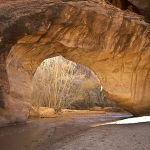
Along the way, you’ll see an arch and natural bridge.
This route is the perfect blend of sweetness and spice — a mostly easy stroll (if not sloggy at times) with occasional obstacles and the option to scramble up to Phipps Arch and Maverick Bridge.
Hike Phipps Wash
From the parking area, cross the road and look for a boot-beaten path that heads northeast. Drop off the right side of a peninsula, and bend back around its base to the left. An intermittent trail leads to the bottom of the wash. It’s easy to get off track — if you do, just keep heading down toward the bottom of the drainage, taking care not to step on cryptobiotic soil crusts.
Continue downstream, bypassing the first dryfall on the left. You drop into the main branch of Phipps Wash around 0.8 mile, descending a steep red and white slickrock slab to reach the bottom.
Navigation is fairly straightforward from here — continue downstream. The sandy wash makes for slow walking at times, and another dryfall forces you left again. Keep your eyes peeled for inscriptions by Escalante cattlemen on the canyon walls (a few minutes past the second dryfall, and again when the north fork of Phipps Wash joins the main canyon around 1.9 miles).
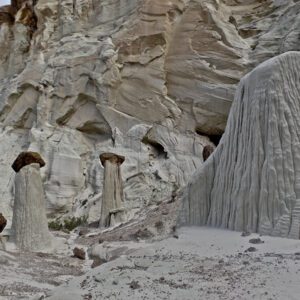
Willows, cottonwood trees, and other vegetation begin to fill the canyon floor. Depending on the season, you may have to hop across an intermittent stream. Keep track of the tributaries coming in below the north fork junction. Phipps Arch, detailed below, is in the third one coming in from the east (right side of the canyon).
Optional Phipps Arch spur trail
Here’s where the spice comes in — the route up to Phipps Arch is a scramble. You should be comfortable climbing up and down steep slickrock pitches. To get there, hike into the tributary and follow one of many cairned routes up the canyon’s north wall. Ascend a series of ledges to reach the base of the arch. Return back to the main canyon.
To Maverick Bridge
You’re almost there. Continue down Phipps Wash toward the Escalante River for another half mile. Turn into the tributary on the left, and hike a short way via a worn footpath to Maverick Bridge.
When you’re ready to return, hike the route in reverse back to your vehicle.
Directions to the trailhead
From Escalante, head east on Hwy 12 for about 10 miles. Turn right onto Spencer Flat (Old Sheffield) Road, cross a cattle guard, and continue for 2.2 miles. There’s a pull-off on the right where you can park your vehicle.