Grand Canyon-Parashant National Monument is a remote landscape filled with colorful vistas, deep canyons, and stately mountains
It encompasses four wilderness areas and part of the Shivwits Plateau near the lower end of the Grand Canyon. Grand Canyon-Parashant National Monument lies at the junction of three major ecoregions—the Colorado Plateau, Mohave Desert, and Basin and Range Province— and is nearly equal in acreage to neighboring Grand Canyon National Park.
Visiting the monument
While everyone has heard of Grand Canyon National Park, few know of its neighboring sister monument—Grand Canyon-Parashant. Located in the northwest corner of Arizona, this remote area receives a fraction of the number of Grand Canyon visitors but protects over a million acres of land with similar cultural, geological, and scenic values.
Much of the monument remains unexplored, with only five percent of the protected land having been surveyed. You can see remnants of ranching, mining, and timber cutting at sites like Tassi Ranch, Nixon Sawmill, and Pa’s Pocket Line Shack. But human history here dates back much further. Thousands of archaeological sites—petroglyphs, artifacts, agave roasting pits, pueblos—document the cultures and lifestyles of the Ancestral Puebloan and Southern Paiute cultures. The monument’s name derives from an early translation of a Paiute family name “Parashonts,” meaning “elk or large deer standing in water.”
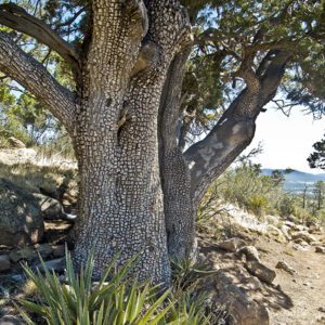
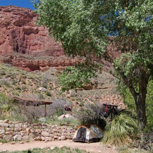
The “Grand Canyon” part of the monument’s name refers to the watershed. Adjacent to the west end of the Colorado River, the monument is an important part of Grand Canyon’s hydrology. Tributaries lead into the Colorado River, and many springs, including Tassi and Pakoon, lie within monument boundaries. These are fantastic places to visit; lush vegetation provides a stark contrast to the surrounding arid lands. Plant life in Grand Canyon-Parashant National Monument is diverse, reflecting a 6,000-foot elevation range. Joshua trees and century plants grow at lower elevations, stepping up to piñon pine and juniper woodlands, to higher-elevation ponderosa pine forests.
The monument stands at an important intersection of three distinct ecoregions—the Basin and Range Province, the Mohave Desert, and the Colorado Plateau converge within its boundaries to create a varied and interesting landscape. This highly faulted topography contains canyons, mountains, cinder cones, and basalt flows that are the adventurer’s dream. The Grand Wash Cliffs, Mt. Trumbull, and Mt. Dellenbaugh provide excellent hiking opportunities. Today, the National Park Service and Bureau of Land Management co-manage several national monuments, but Grand Canyon-Parashant was the first protected area to share leadership between these two organizations. If you go well prepared, you will find this rugged monument embodies the spirit of the West and awaits your exploration!
Getting there
No paved roads access the monument, and road conditions deteriorate quickly after rainstorms. Both agencies (NPS and BLM) recommend traveling in high-clearance vehicles and carrying two spare tires since there are no services in the monument. Don’t depend on cell phone service, which is spotty at best. Always carry extra water and food.
Directions: Heading south on I-15 through St. George, Utah, take exit 8 towards St. George Blvd. Turn left onto St. George Blvd, and continue east until you can take the first right onto S. River Road. Follow this road for about 8 miles to the Utah/Arizona border. The road continues south as BLM 1069, and connects you to many access points within Grand Canyon-Parashant National Monument. Use a detailed map to navigate to your desired destinations.