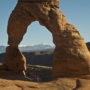
Arches National Park is a testament to nature’s architecture—a place full of bridges, arches, windows, towers, and fins, all built of stone.
The park includes more than 2,000 natural arches, with scenic drives and short hikes highlighting these impressive formations. Located just outside Moab, Utah, Arches National Park is the gateway to Utah’s slickrock country, which contains the greatest density of natural arches in the world.
Visiting the park
The low-key entrance to Arches, off Highway 191 north of Moab, Utah, gives few hints of the geologic curiosity awaiting visitors on the other side of the canyon walls. But word has gotten out. More than a million people now come annually to see the unworldly scene.
The park includes more than 2,000 named arches and countless openings that might one day erode into “official” arches. To technically be considered an arch, the opening must span at least three feet in one direction.
Many people know of Arches from writer Edward Abbey’s Southwest classic, Desert Solitaire, a book based on his experience as a seasonal park ranger in Arches during 1956 and 1957. The Arches that Abbey knew was quite different from today. Then a national monument, Arches was rugged, remote, difficult to get to, and sparsely visited. The dirt roads were dusty, infrastructure rare. The year after Ed Abbey left his post, the National Park Service began paving the main park road, dramatically increasing accessibility and visitation. Today, Arches is a popular drive-through park, featuring short hikes and scenic overlooks of the incredible geology.
Trails: Delicate Arch Trail | Devil’s Garden and Primitive Loop | Park Avenue Trail | Sand Dune & Broken Arch Trail
Campground: Devil’s Garden Campground
Timed-entry system: Visitors must obtain a $2 per-vehicle ticket for visits to the park from 6 a.m. to 5 p.m., April 3 through October 3. Secure your reservation ›