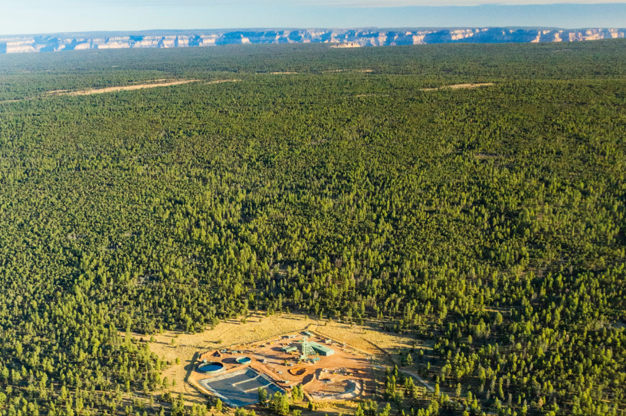
Analysis of groundwater sampling across the Grand Canyon region reveals average arsenic levels at Pinyon Plain uranium mine seem unusually high.
FOR IMMEDIATE RELEASE
GRAND CANYON, AZ — A new analysis of 32 years of existing groundwater sampling at 40 Coconino Aquifer well and spring sites across the Grand Canyon region shows that average arsenic levels at the controversial Pinyon Plain uranium mine (formerly Canyon Mine) seem uncharacteristically high.
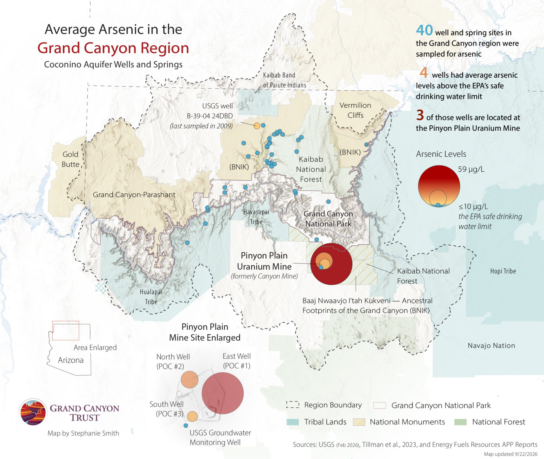
The 40 wells and springs were sampled for arsenic at various times between 1993 and 2025. All 40 are from the Coconino Aquifer. Of the 40 sites sampled, only 10% (four sites) were found to have average arsenic levels above EPA safe drinking-water levels. Three of those four were located at Pinyon Plain Mine, just south of Grand Canyon National Park.
Pinyon Plain uranium mine is located inside the boundaries of Baaj Nwaavjo I’tah Kukveni – Ancestral Footprints of the Grand Canyon National Monument, and on the ancestral lands of the Havasupai Tribe, near the tribe’s sacred mountain, Red Butte. It sits above the deep Redwall-Muav Aquifer, which feeds the blue-green waters of Havasu Creek.
“If Havasu Creek is contaminated, there is no backup water system waiting for us. There is no second river we can turn to,” said Melinda Yaiva, chairwoman of the Havasupai Tribe. “We are asking that elevated arsenic be investigated, not normalized,” Yaiva explained.
Key findings
The EPA safe drinking-water limit for arsenic is 10 micrograms per liter. Out of 40 Coconino Aquifer sites across the Grand Canyon region:
- The highest average arsenic level was found in Pinyon Plain Mine’s East Monitoring Well. Average arsenic in the well was 58.7 micrograms per liter, 5.87 times the safe limit.
- The second-highest average arsenic level was found in Pinyon Plain Mine’s North Monitoring Well. Average arsenic in the well was 26.9 micrograms per liter, 2.69 times the safe limit.
- The third-highest average arsenic level was found in Pinyon Plain Mine’s South Monitoring Well. Average arsenic in the well was 18.1 micrograms per liter, 1.81 times the safe limit.
- Out of 40 total sites, the only other site with an average arsenic level above the drinking-water limit was a U.S. Geological Survey well north of the Grand Canyon, where average arsenic was about 1.2 times the safe limit.
The Coconino Aquifer sits above the deeper Redwall-Muav Aquifer, which feeds many seeps and springs in the Grand Canyon. Studies show the two aquifers are hydrologically connected.
According to Dr. David Kreamer, emeritus professor at the University of Nevada, Las Vegas and past president of the International Association of Hydrogeologists, there are “multiple lines of evidence that have shown that the upper aquifer and the lower aquifer are connected.”
According to Dr. Laura Crossey, emerita professor at the University of New Mexico and American Association for the Advancement of Science and Geological Society of America fellow, “We know from the spring chemistry emerging from the RM [Redwall-Muav] Aquifer that we have recently recharged water, we have things like CFCs…So that right there tells you directly that there is some connection.”
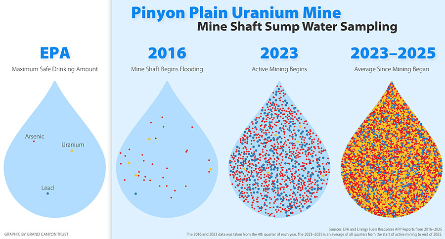
Possible groundwater contamination has long been a concern at Pinyon Plain uranium mine, which has been commercially mining since December 2023. The mine punctured an aquifer in 2016 during mine development. By the end of 2025, more than 80 million gallons of groundwater, showing higher and higher levels of uranium and arsenic, had been pumped out of the sump at the bottom of the mine.
The three mine-operated Coconino Aquifer monitoring wells weren’t installed until 2021, five years after the mine development first significantly disturbed groundwater. The single USGS well located just outside the mine site was drilled in 2017.
In 2026, the Arizona Department of Environmental Quality approved an amendment to the mine’s aquifer protection permit to allow higher arsenic in the mine’s North Monitoring Well based on mine operator Energy Fuels Resources’ assumption that arsenic increases were merely natural and coming from off the mine site. Scientists suggested reasonable ways that hypothesis could be tested. The agency chose not to take their suggestions. When the Havasupai Tribe appealed the agency’s decision, rather than debate the science, the agency sought and received dismissal of the appeal on the grounds that the Havasupai Tribe lacked standing.
“For the Havasupai Tribe, that raises a very basic question,” said Havasupai Tribal Chairwoman Melinda Yaiva. “Why should the state allow arsenic levels to rise higher before requiring monitoring, investigation, and protective action?”
“The mine’s argument right now is that natural background arsenic is being drawn in and that is what is creating the high arsenic levels,” said Dr. Kreamer. “The natural background all around the mine is much, much lower, 20 to 30 times lower than what’s being seen in the monitoring wells. If arsenic concentrations in groundwater outside the mine are lower than inside, how can drawing low concentration outside increase the already high and increasing arsenic concentrations inside the property? You would think that adding cleaner water, groundwater from outside, shouldn’t it dilute the high concentrations inside?” Kreamer added.
“We should not expect to wait until our water is contaminated before our concerns are taken seriously,” said Chairwoman Yaiva. “We should not have to prove that contamination is inevitable before regulators act cautiously. And we should not be told that because our village is miles away from the mine, the risk can simply be dismissed. Groundwater does not follow political boundaries, reservation boundaries, or lines drawn on a map. This is precisely why the science matters, and why the concerns raised by independent experts must be taken seriously,” Chairwoman Yaiva added.
Dr. Crossey added, “We can get at the chairwoman’s point that groundwater can flow the distance between Pinyon Plain Mine and Supai Village by looking at tracer studies that have been conducted over the past two decades, which have shown that water in the Grand Canyon region does flow comparable distances. It’s not out of the question.”
“In the investigation that the mine submitted to ADEQ for permit modification approval, they did not really consider in any depth other alternate explanations for the rise in arsenic,” said Dr. Brad Esser, a retired research scientist in environmental radiochemistry who previously worked at Lawrence Livermore National Laboratory. “This is a kind of a failure of the monitoring program, the regulatory process, because at the present time, we don’t really know why the arsenic is rising because it hasn’t been thoroughly investigated. And that leaves us unable to predict future concentrations of arsenic and of uranium in on- and off-site groundwater. And it also leaves us unable to develop mitigation plans to prevent further contamination,” Esser said.
“Regulators and lawmakers need to know that the public is exhausted by the use of technical jargon and technicalities to dismiss valid concerns about mining impacts on groundwater,” said Amber Reimondo, energy director for the Grand Canyon Trust. “The Havasupai Tribe and community members have insisted for decades that uranium mining doesn’t belong near the Grand Canyon, in part because it poses an inherent risk to water. If regulators find themselves needing to explain what categories of groundwater contamination are and aren’t allowed, it proves the point,” Reimondo added.
Methodology
Stephanie Smith, GIS director for the Grand Canyon Trust, downloaded well and spring sites from the USGS water quality database for Arizona and used GIS to identify those within the Colorado River study area defined by Tillman, et. al in the paper “An assessment of uranium in groundwater in the Grand Canyon region.”
Smith then cross-referenced the sites with USGS records and scholarly sources to identify those likely tapping the Coconino Aquifer, excluding any with unknown well elevations or spring sources and any sites lacking arsenic data.
Smith also reviewed the Arizona Department of Environmental Quality database, which contained no additional arsenic results for sites in the Grand Canyon region study area. However, the Arizona Department of Environmental Quality publishes sampling reports for Pinyon Plain uranium mine that include the mine’s three on-site Coconino Aquifer monitoring wells.
Smith identified 40 sites with arsenic results. Samples spanned 1993-2025. Four sites were sampled in 1993, while the rest were sampled between 2002 and 2025. Only seven sites appeared to be sampled annually. Since the sampling dates varied, Smith averaged results for each site.
Watch the virtual press conference
Maps and graphics
Contact
Amber Reimondo, Energy Director, Grand Canyon Trust, areimondo@grandcanyontrust.org, (928) 286-3361
Photos for media use
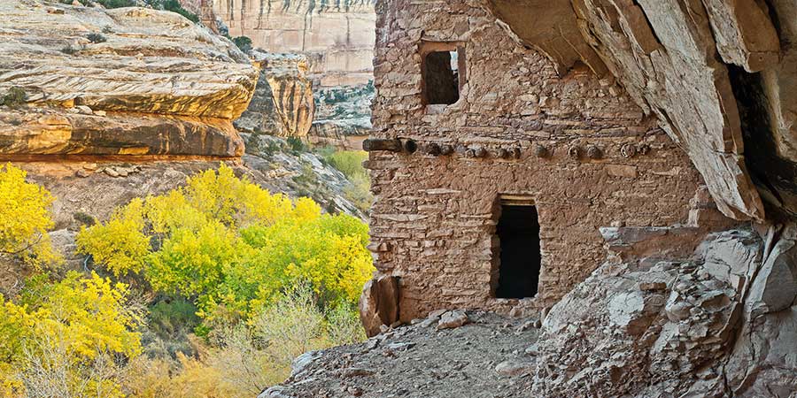
Photo Gallery
Places cut from Bears Ears National Monument
Photo Gallery
Bears Ears scenics
Photo Gallery