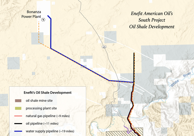
This map shows the risk of fatal accidents along the more than 300-mile transportation route from Canyon uranium mine (renamed Pinyon Plain Mine) near the Grand Canyon to the White Mesa uranium mill. Four of the five most dangerous sections along the route are on the Navajo Nation. See a photo gallery of the haul route, […]
Resources › Enefit Oil Shale Development Map
Enefit Oil Shale Development Map

Resource - map credit Stephanie Smith
Maps and graphs may be used for non-commercial purposes provided that they are not altered or edited and they are appropriately credited. All map products should be credited to Stephanie Smith, Grand Canyon Trust, unless otherwise noted. A hyperlink to the Grand Canyon Trust website is appreciated.
For higher quality images or custom sizing please contact our communications director, Ashley Davidson, at adavidson@grandcanyontrust.org.
Related Resources
This interactive timeline offers a brief history of Canyon Mine (renamed Pinyon Plain Mine), a controversial uranium mine near the Grand Canyon.
This map shows active mining claims, including various uranium mines, inside the boundaries of Baaj Nwaavjo I’tah Kukveni Grand Canyon National Monument The map was produced using data from the Bureau of Land Management and updated in June 2024. Download a PDF of the map › Maps and graphs may be used for non-commercial purposes […]