Worldwide Radioactive Wastes and Bears Ears Map

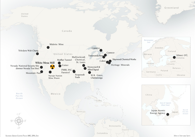
The White Mesa Mill in southeastern Utah has transformed its business model to operate as a waste-disposal service, charging millions in fees to process and discard other industrial and military facilities’ radioactive wastes. More than 15 different radioactive waste streams have been approved for shipment to the mill from contaminated sites across the United States and as far away as Canada, Europe, and Japan.

Worldwide sites map with insets

Worldwide Radioactive Wastes and Bears Ears

Download a PDF of this map


Worldwide sites map

Worldwide Radioactive Wastes and Bears Ears

Download a PDF of this map

Maps and graphs may be used for non-commercial purposes provided that they are not altered or edited and they are appropriately credited.

All map products should be credited to Stephanie Smith, Grand Canyon Trust, unless otherwise noted. A hyperlink to the Grand Canyon Trust website is appreciated.

For higher quality images or custom sizing please contact our communications director, Ashley Davidson, at adavidson@grandcanyontrust.org

Related Resources

Line graph showing average arsenic levels (2017–2025) at Pinyon Plain Uranium Mine wells, with some readings exceeding EPA’s safe drinking water limit. Inset map marks well locations.
Rising arsenic levels in monitoring wells at Pinyon Plain uranium mine raise concerns about possible contamination of groundwater in the Grand Canyon region.