Map of Two Proposals to Dam the Little Colorado River

Map of the proposed Salt Trail Canyon project showing the little Colorado River, the gorge, and where dams and reservoirs would go

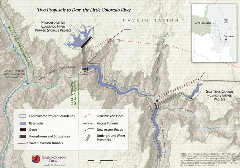
A Phoenix company has proposed two hydroelectric projects (each with two dams) in the Little Colorado River Gorge, mere miles from Grand Canyon National Park. This map shows the proposed boundaries for the Little Colorado River Pumped Storage Project, and the Salt Trail Canyon Pumped Storage Project.

Two proposals map

Download a PDF of this map

Maps and graphs may be used for non-commercial purposes provided that they are not altered or edited and they are appropriately credited.

All map products should be credited to Stephanie Smith, Grand Canyon Trust, unless otherwise noted. A hyperlink to the Grand Canyon Trust website is appreciated.

For higher quality images or custom sizing please contact our communications director, Ashley Davidson, at adavidson@grandcanyontrust.org

Related Resources

Advocate Magazine cover with image of red packraft on clear blue water in a cave in the Grand Canyon
The fall 2025 edition of the Grand Canyon Trust’s Colorado Plateau Advocate magazine, including a deep dive into the Grand Canyon’s ancient groundwater.
Graphs display Lake Powell and Lake Mead Levels from 2000 to 2023, showing current elevations and distances to power and dead pool thresholds in feet.
How much water is in Lake Powell and Lake Mead? See a live feed of distance above power pool and dead pool at both reservoirs.