Map of Mining Claims Around Grand Canyon Prior to 2012

A map that shows more than 8,000 mining claims around the Grand Canyon
Stephanie Smith

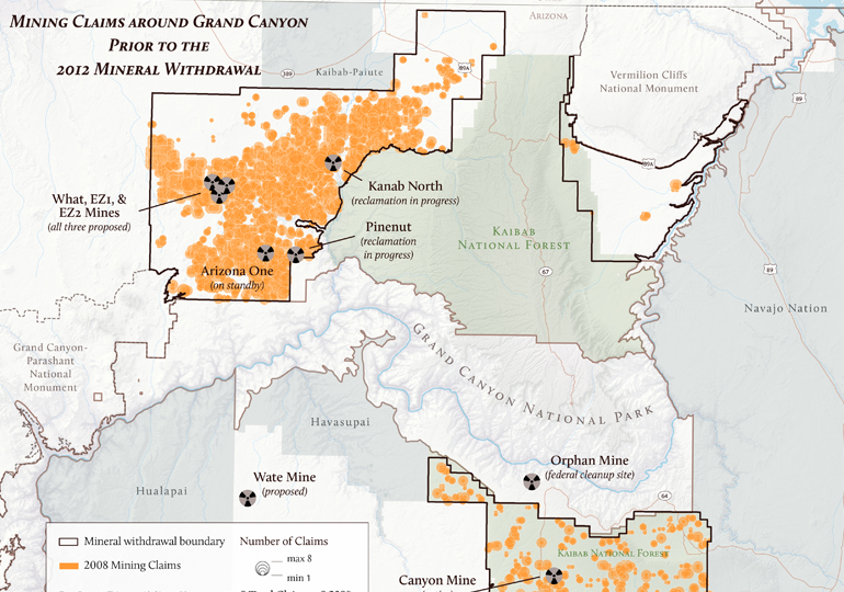
In 2008, there were over 8,000 mining claims on public lands surrounding Grand Canyon National Park. According to the 2012 Northern Arizona Mineral Withdrawal Record of Decision, which banned new mining claims on about 1 million acres of public land surrounding the park for a period of 20 years, there were over 10,000 mining claims on these lands in 2009.

Mining claims around Grand Canyon prior to 2012 mining ban

Download a PDF of this map

Maps and graphs may be used for non-commercial purposes provided that they are not altered or edited and they are appropriately credited.

All map products should be credited to Stephanie Smith, Grand Canyon Trust, unless otherwise noted. A hyperlink to the Grand Canyon Trust website is appreciated.

For higher quality images or custom sizing please contact our communications director, Ashley Davidson, at adavidson@grandcanyontrust.org

Related Resources

Dragon Bravo Fire Map showing the locations and burn perimeters of the White Sage and Dragon Bravo wildfires in 2025 near Grand Canyon National Park and Kaibab National Forest, with affected areas shaded in orange.
See a map of the areas the Dragon Bravo and White Sage fires burned on the north rim of the Grand Canyon in the summer of 2025, destroying the lodge and numerous other park buildings.
Advocate Magazine cover with image of red packraft on clear blue water in a cave in the Grand Canyon
The fall 2025 edition of the Grand Canyon Trust’s Colorado Plateau Advocate magazine, including a deep dive into the Grand Canyon’s ancient groundwater.