Map of Active Mining Claims Within Grand Canyon Withdrawal Area May 2022

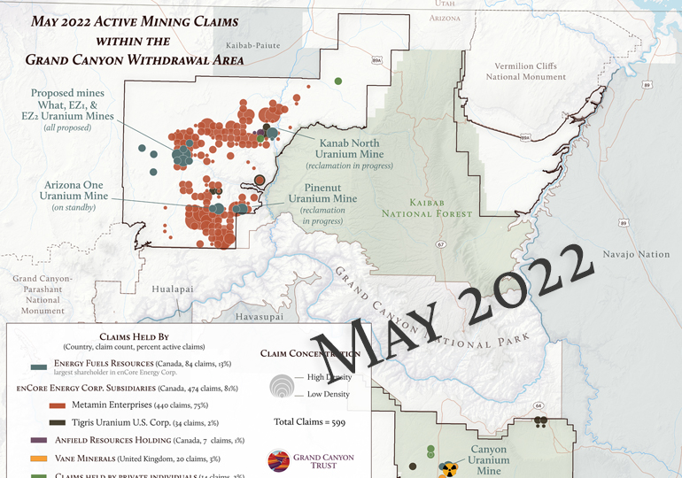
This map shows active mining claims within the Grand Canyon mineral withdrawal area. The map was produced using data from the BLM LR2000 Land and Mineral Systems Report, downloaded in May 2022. The map is updated from a 2020 version ›

Grand Canyon active mining claims

Download your copy

Maps and graphs may be used for non-commercial purposes provided that they are not altered or edited and they are appropriately credited.

All map products should be credited to Stephanie Smith, Grand Canyon Trust, unless otherwise noted. A hyperlink to the Grand Canyon Trust website is appreciated.

For higher quality images or custom sizing please contact our communications director, Ashley Davidson, at adavidson@grandcanyontrust.org

Related Resources

Dragon Bravo Fire Map showing the locations and burn perimeters of the White Sage and Dragon Bravo wildfires in 2025 near Grand Canyon National Park and Kaibab National Forest, with affected areas shaded in orange.
See a map of the areas the Dragon Bravo and White Sage fires burned on the north rim of the Grand Canyon in the summer of 2025, destroying the lodge and numerous other park buildings.
Advocate Magazine cover with image of red packraft on clear blue water in a cave in the Grand Canyon
The fall 2025 edition of the Grand Canyon Trust’s Colorado Plateau Advocate magazine, including a deep dive into the Grand Canyon’s ancient groundwater.