Mining Threats Map Baaj Nwaavjo I’tah Kukveni Grand Canyon National Monument

Map illustrating mining threats to the Baaj Nwaavjo I'tah Kukveni - Ancestral Footprints of the Grand Canyon National Monument, highlighting uranium sites and tribal lands.

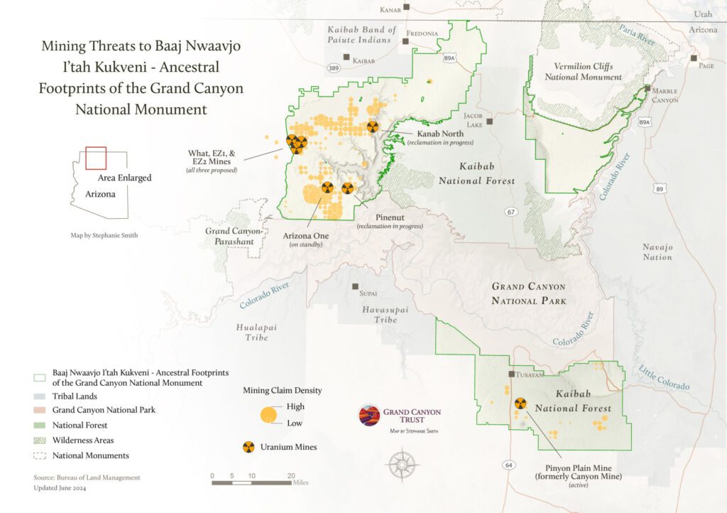
This map was produced using data from the Bureau of Land Management and updated in June 2024. It shows active mining claims, including various uranium mines, inside the boundaries of Baaj Nwaavjo I’tah Kukveni Grand Canyon National Monument.

Map of mining threats in the Grand Canyon region” width=

Download a PDF of the map

Maps and graphs may be used for non-commercial purposes provided that they are not altered or edited and they are appropriately credited.

All map products should be credited to Stephanie Smith, Grand Canyon Trust, unless otherwise noted. A hyperlink to the Grand Canyon Trust website is appreciated.

For higher quality images or custom sizing please contact our communications director, Ashley Davidson, at adavidson@grandcanyontrust.org

Related Resources

Letter addressed to Mr. Suess objecting to the Department of Interior’s expedited review of a mine plan modification for the Velvet-Wood uranium mine.
The Grand Canyon Trust’s comments objecting to the Department of Interior’s expedited review of a mine plan modification for the Velvet-Wood uranium mine.
A December 2024 poll of 500 voters across Utah found strong public support for Bears Ears and Grand Staircase-Escalante national monuments
A December 2024 poll of 500 Arizona voters by public opinion research firm GQR found strong public support for Baaj Nwaavjo I’tah Kukveni – Ancestral Footprints of the Grand Canyon National Monument.