 by Cerissa Hoglander, Land Conservation Associate
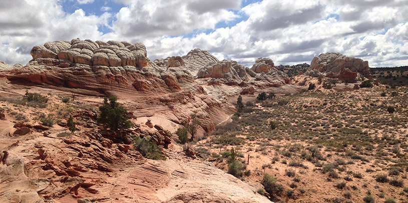
You may not recognize this national monument by name, but the Vermilion Cliffs are one of the most visible landforms on the Arizona Strip. The remoteness and lack of roads add to the wonder of this little-known monument wedged among its more famous neighbors: Grand Staircase-Escalante, Zion, and the Grand Canyon. But despite its anonymity, there’s a good chance you’ve caught a glimpse of it driving to the north rim of the Grand Canyon or paging through a southwestern highlights guide.
But this iconic landscape is at risk, along with 26 other national monuments, of losing protection. Secretary of the Interior Ryan Zinke, per President Trump’s executive order, is reviewing several monuments designated by Obama, Bush, and Clinton under the guise of public input concerns during the initial monument designations. The window for our voices to be heard for protecting these monuments through public comment closes July 10.
We’ve already written about why Bears Ears and Grand Canyon-Parashant should be kept as national monuments. Now, let’s explore another Colorado Plateau gem threatened by Trump’s executive order: Vermilion Cliffs National Monument.
Located near the Arizona/Utah border, west of Lake Powell, Vermilion Cliffs National Monument gets its name from the 3,000-foot sandstone escarpment rising skyward from House Rock Valley in vibrant red hues. The Vermilion Cliffs are important habitat for the endangered California condor and countless other wildlife, and they seep rain water to life-giving springs in the valley below.
On the north side of the monument, the narrows of the Paria Canyon stretch for miles, building the muddy slip of the Paria River before it churns with the emerald water of the Colorado River at Lee’s Ferry.
This remote and wild landscape covers 280,000 acres of the Arizona Strip and provides spectacular sights for the intrepid explorer. At Vermilion Cliffs, visitors backpack in the stunning Paria Canyon, and navigate the narrows of Buckskin Gulch. They pine for a chance to win a permit for the Wave, to see its wind swept red and gold sandstone curves that bend and catch light. Or, they brave rugged and sandy roads to adventure on top of the Paria Plateau to see other-worldly geologic features and experience the area’s rich cultural history.
Because of the geologic, cultural, and ecological significance of this remote and rugged landscape, the proclamation for Vermilion Cliffs states “that it would be in the public interest to reserve such lands as a national monument.”
We couldn’t agree more.
Here, we lay out the questions Secretary Zinke may consider in his evaluation of Vermilion Cliffs National Monument, and provide some facts in response that you can use to help craft your comments to the Interior.
Vermilion Cliffs is a landscape where humans have crossed, explored, and lived for over 12,000 years. From Paleo-Indian hunters, to Archaic hunters and gatherers, to ancestral Puebloans, to nomadic Paiutes, to the Spanish padres of the Dominguez-Escalante expedition, to Mormon pioneers and homesteaders, the range and richness of cultural history documented here is extensive.
At the Trust, we’re deeply invested in the science-based conservation of this incredible landscape and have worked tirelessly with our partners to preserve its diversity. Together, we’ve completed extensive archeological surveys through the Kaibab-Vermilion Cliffs Heritage Alliance, trekked across the Paria Plateau to document a diversity of wildlife species, including 19 different bat and 34 different songbird species, and sweated hours wrenching weeds to improve the flow of the Paria River and other waters. Vermilion Cliffs is a natural wonder and a national treasure, and it’s in the public’s best interest to stay protected.
Monument designation does not necessarily limit the multiple uses allowed on federally-managed public lands. On Vermilion Cliffs, recreation, hunting, and off-highway vehicle riding are all managed uses. Livestock are also grazed on certain parcels of this monument through a science-based conservation partnership with the Grand Canyon Trust, a multi-generational ranching family, and others.
The lands designated in the monument proclamation were already federally-managed lands. In fact, 112,500 acres of the Paria Canyon and the Vermilion Cliffs themselves were first designated as wilderness by a bipartisan Congress in 1984. Most of this already-designated wilderness made it into the monument boundaries.
Communities in Arizona’s Coconino County experienced “strong growth” since the designation of Vermilion Cliffs National Monument, increasing jobs by 25 percent and real per capita income by 24 percent. Local group Friends of The Cliffs and heritage programs are working to protect the monument, including its tribal resources and cultural history.
Please take a moment to speak out for the protection of this important monument. Any comment — from your brief, personalized message to a longer, persuasive essay — is important. Below we’ve laid out a few tips that can help make your message to the secretary stand out:
Thank you for taking the time to speak out for this important and incredible landscape. National monuments are part of our American history and are protected for all of us. Let’s keep them public.
Proposal to build massive communications tower on state lands inside Bears Ears National Monument withdrawn
Read MoreThe Navajo Nation and communities along the haul route oppose uranium transport from Grand Canyon region mine.
Read MoreDeveloper's attempt to dam a canyon near the confluence of the Colorado and Little Colorado rivers halted.
Read More